
This time last year Met Eireann released three weather warnings, as eight counties faced the threat of flooding. With the April Showers approaching, it seems like a good time to assess the geography of flood risk in Ireland. Using our risk mapping platform Perilfinder™, using a detailed 3D flood model from our partners in JBA, we can get an overview of where the greatest risk is. As output, we have calculated the number of residential buildings, from the Eircode database, that are at significant risk of flooding in each county. So where does the greatest risk lie?
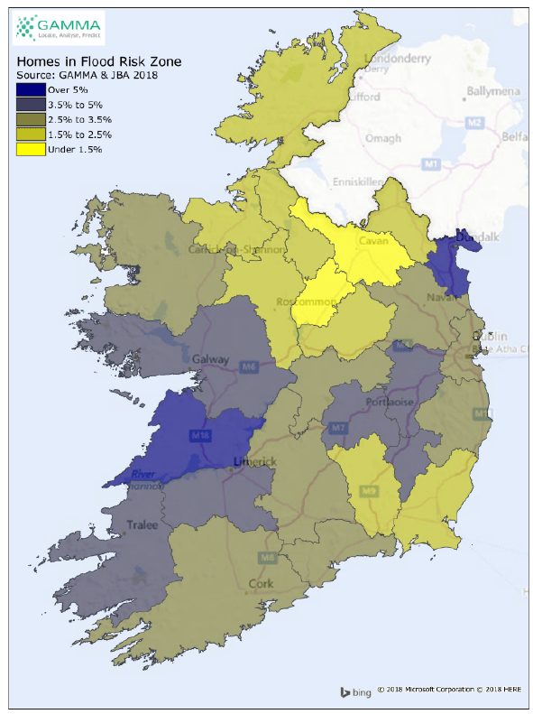
As a percentage of total housing stock, the two outstanding counties with the highest risk score are Co Clare and Co Louth. Clare has just over 10% of its housing stock currently classified in areas deemed of significant risk in the flood model, and Louth’s risk is just under this at 9%. The two counties are scoring highest because they are at risk of both coastal and river flooding and this brings more homes into the reckoning. At the other end of the scale, Longford is the place you are likely to remain driest in your abode, with only 1% of the housing stock under significant threat of flooding. Cavan and Westmeath also have a relatively low percentage of residences in high flood risk zones, at around 1% and 2% respectively.
In absolute terms, the county with the highest count of residential buildings at risk is as expected Dublin, with 12,347 residences at risk, followed by Cork with 6,722 and then Clare with 5,273.
At a national level, just under 60,000 residences are at significant risk from flooding, or just over 3% of the residential housing stock.
As well as an overall score, flood risk is further categorised in the model by the source of risk, covering river, coastal and surface and by likely water depth, so that damage impact can be assessed. For further details contact us at info@gamma.ie.
@ 2019 Gamma.ie by Feargal O’Neill
About Perilfinder™
Gamma’s Perilfinder™ risk mapping platform is a global cloud-hosted underwriting solution used by insurers to assess environmental risk. Perilfinder™ is a complete risk assessment and reporting solution for underwriters, incorporating address matching, rooftop-level geocoding, risk and accumulation scoring, and spatial catastrophe models. Technically advanced yet user-friendly, Perilfinder™ helps its users control their risk portfolios by better managing policy accumulations and through identifying geographical perils in real time. Perilfinder™ is a world-class, no-fuss, intuitive and feature-rich location intelligence system.
Book a demo of Perilfinder™ today!
Find out how Gamma can help your organisation today.
@2024 Gamma. All Rights Reserved