
We may be in the depths of winter and experiencing an unusual cold snap at present here in Ireland, but 2022 was the second hottest year in Europe on record, despite the presence of a persistent El Nino event in the Pacific Ocean, which typically results in a cooler than average year. Temperatures in Dublin in July broke all time records in the city.
Because cities have a lot of impervious surfaces such as asphalt roads, concrete buildings and much lower levels of vegetation than surrounding areas, the temperature tends to be significantly higher in large urban areas than in the surrounding countryside. The Urban Heat Island effect has been understood since the 1960s however recent developments such as the launching of satellites capable of measuring surface temperatures at a very high resolution allow the Urban Heat Island effect to be examined in detail.
Landsat 8 launched in 2013 and Landsat 9 launched in 2021 by NASA have thermal sensors that have a resolution of 100m x 100m. This is detailed enough to identify single large industrial buildings and small parks. The result is that we can examine the distribution of excess heat across cities and see areas within the city that are more prone to extreme heat than others. It can also identify cooler areas within the city. This kind of analysis is particularly important in global cities that experience dangerous levels of heat in the summer, but even in Ireland we can see quite a large difference across cities with temperature gradients in excess of 15C.
To perform this analysis Gamma looked at Urban Heat Islands using Landsat 8 imagery for the June-August period across 2013 to 2022 in both Cork and Dublin. We automatically removed satellite imagery that had any significant cloud cover, which is always an issue with this particular type of imagery in Ireland. We then trained a model on small rural and urban areas to classify and quantify the Urban Heat Island effect.
Both Cork and Dublin exhibit areas that see excess heat in summer. These are broadly three types of areas, that exceed typical heat levels. Firstly the commercial core areas of the city where there is a lack of vegetation, secondly high density residential areas typically where the houses have yards rather than gardens and the streets do not have tree cover and finally industrial facilities that are producing heat as part of their operations.
Looking at the distribution of these across Cork, the city centre is clearly prone to excess heat in the summer, despite the cooling influence of the Lee. The Penrose Wharf area is one of the hottest in the city. Industrial facilities around the city also jump out, with Hollyhill, Little Island, Rushbrook by Cobh and Midelton showing peaks of over 15C above the average across the Cork City area.
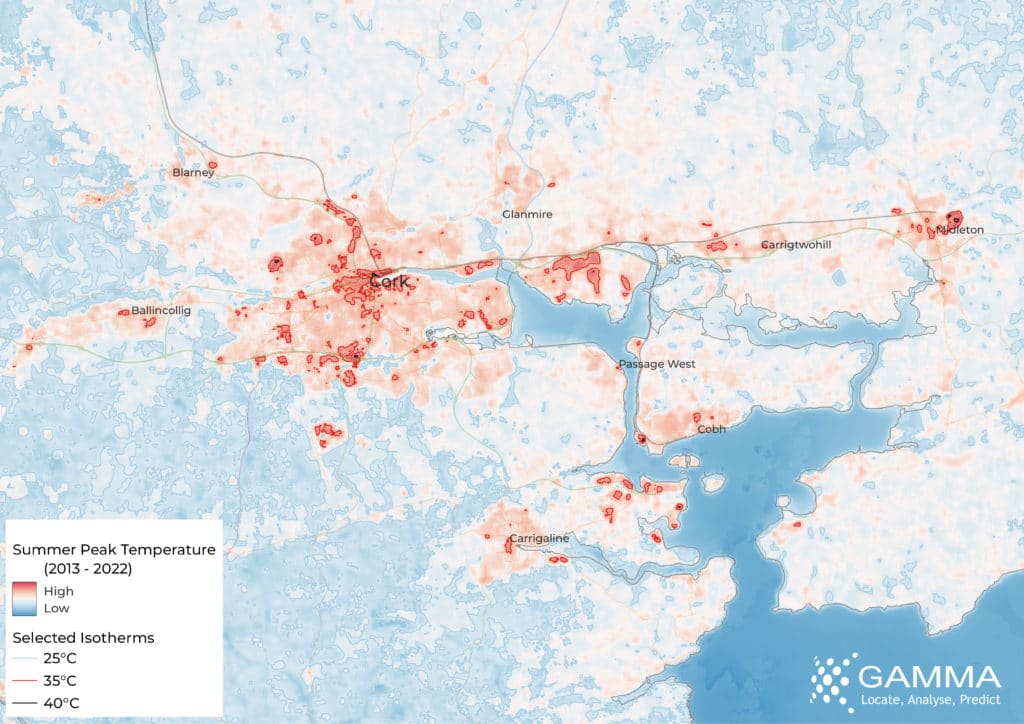
Image 1: Cork Summer Peak Temperature (2013 – 2022)
Dublin has a significantly larger proportion of it’s area that sees above average heat compared to Cork. However there are fewer areas in Dublin that see over 15C above average when compared to Cork which is indicative of the differing industrial bases of the two cities. In Dublin the industrial areas in the west of the city from Park West to Greenhills clearly stand out, as does high density housing areas such as Stoneybatter and the Liberties. The retail core area around Henry Street towards the Fruit Market also jumps out. The city’s parks are clearly the places to cool down on hotter days. Phoenix Park is an oasis of cool, obviously, but much smaller parks such as Stephen’s Green and Merrion Square can be seen in the data. While the Liffey has a limited cooling effect in the city centre, the course of the Dodder across the southside of Dublin spreads cooling in that part of the city.
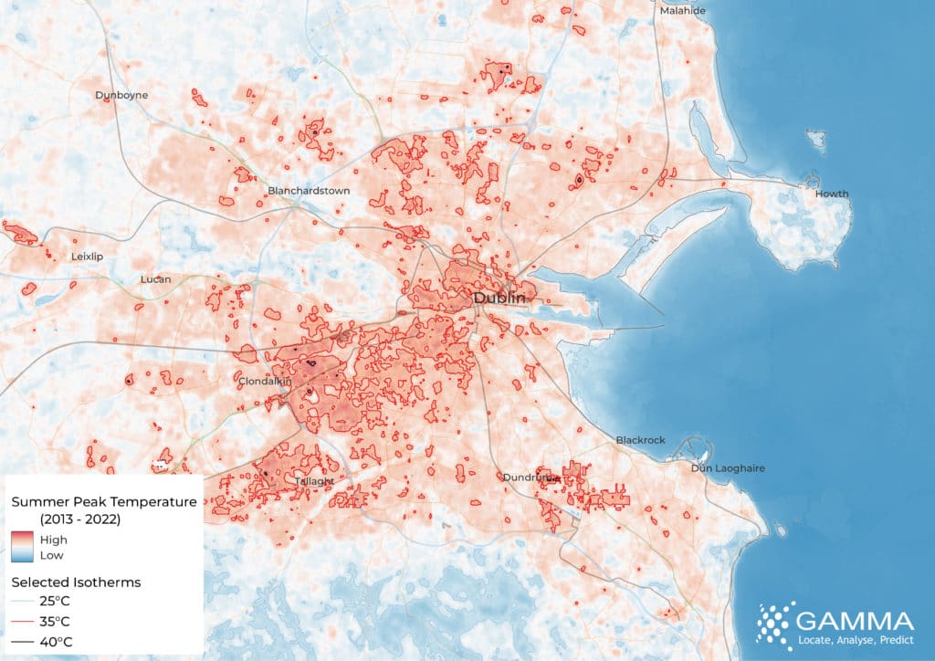
Image 2: Dublin Summer Peak Temperature (2013 – 2022)
Variations in the temperature of 15C and above are common in cities across the globe, matching figures were seen when conducting this same analysis in Washington DC, while in India the city of Delhi saw gradients in excess of 25C during the heatwave there in May 2022.
Tracking these changes over time will be a valuable analytical capability allowing for the detailed monitoring of the impacts of climate change at the city block level. The recent launch of Landsat 9 by the United States Geological Survey (USGS) adds a number of improvements to the available data and extends the Landsat programme for at least another 5 years. The programme as a whole has been continually monitoring the Earth’s Surface and Atmosphere since 1972. The European Union has a complementary fleet of satellites operating its Copernicus Earth Observation programme.
@ 2023 Gamma.ie by Richard Cantwell
About Gamma
Gamma is a Location Intelligence (LI) solutions provider that integrates software, data and services to help its clients reduce risk through location intelligence. Established in Dublin, Ireland in 1993, and with offices in Manchester, UK and Bilbao, Spain, the company focuses heavily on cutting-edge research and development projects, leveraging Artificial Intelligence and machine learning.
Find out how Gamma can help your organisation today.
@2024 Gamma. All Rights Reserved